

nick
-
Compteur de contenus
11 -
Inscription
-
Dernière visite
nick's Achievements
")
Newbie (1/14)
-
Bretagne Nord VFR REGIONAL FSX disponible !
nick a répondu à un(e) sujet de dbalternative dans Bretagne Nord VFR REGIONAL (Vol.1)
Oui un regal ! -
Et pas moyen d'y greffer du Photo HD ? Le survol de la chaine himalayenne est impressionant. Mais j'entrevois la difference de philosophie... La philosophie FVFR me va aussi !
-
je reviens à la charge... détaillé jusqu'au brin d'herbe Ils ont modélisé de la même façon la Terre du Milieu, si ça vous prend de vouloir friser les moustaches de Sauron en Cessna... Allez j'arrête affaire à suivre
-
Bonsoir, Je ne suis pas spécialiste des technos 3D, mais je me montrerais moins pessimiste que titipi sur Outerra Je n'ai aucun intérêt là dedans, d'ailleurs je ne vole que sur FSX pour le moment Apparemment le projet avance, une demo est en telech sur le site Les videos de la galerie sont impressionnantes Ce truc intègre un modele de vol open source (http://jsbsim.sourceforge.net/), le meme qu'on retrouve dans Filghtgear Le forum est actif et ça a l'air de promettre Je n'avais pas vu de changements fracassants avec P3D, et il m'a semblé qu'avec Outerra on tenait peut etre qqch de pas mal Enfin, pour l'instant bosser son VFR sur FSX est vraiment top avec les dernieres scenes 3DA Au fait au passage felicitation aux auteurs des didacticiels d'Horizon VFR ! A +
-
AGX - Installeur de définitions Autogen
nick a répondu à un(e) sujet de dbalternative dans Installation de scènes
On sait maintenant à qui on a affaire ! Et ça va se répandre dans la communauté des honnêtes simeurs Une chose est sûre, que cela n'entame pas votre motivation à nous delivrer des produits toujours plus realistes et de qualité comme vous le faites ! On sait qui sont les pros, sans cocorico -
http://www.oculus-rift.fr/ Pour ceux qui ne connaissent pas. Je crois que la simu nous reserve de bons moments...
-
Documentaire sur la PAF
nick a répondu à un(e) sujet de michel78320 dans Comparatifs vol réel / simulé
Merci pour l'info ! -
Oh punaise le copier coller est un peu indigeste... mais tout est sur leur site !
-
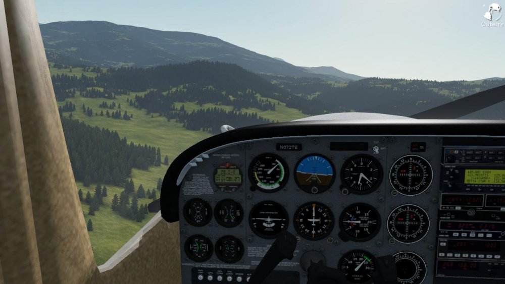
Salut ! Il s'agit d'un nouveau venu dans le rendu 3D apparemment. Les videos sont plutôt alléchantes. "Features Summary: Realistically looking terrain with high detail Unlimited visibility, detail ranging from thousands of kilometers down to centimeters Real time atmospheric rendering Rendering of vast dense forests and grass Seamless transition from space down to the planet surface Adaptive LOD with continuous transitions. Elevation data are preprocessed using special wavelet compression, the required level of detail is extracted effectively on the fly Partitioned compressed dataset can be downloaded progressively over the web Fractal refinement mimicking the natural processes (erosion, rocks, overhangs) Procedural texture generator combining mathematical models and climatic data Bitmap overlays for specific areas Vector data - roads, rivers, land class polygons Uses OpenGL 3.3 Dynamic shadows Fully asynchronous multi-threaded design able to utilize all available CPU cores Terrain and fractal algorithms runing completely on the GPU Stable frame rate system Supports arbitrary and varying resolution of elevation datasets, refined to centimeter resolution by fractal algorithms Embedded web browser allowing for direct web service integration Supports COLLADA 3D model file format Integrates a Flight Dynamics Model library for high fidelity simulation of aircraft, rockets Global physics engine for simulation of vehicle physics and collision detection" voilà les specifications... Et ça fonctionne très bien avec l'Oculus Rift (en phase béta pour le moment) L'Oculus avec FSX pourrait être très bien aussi soit dit en passant !
-
Bonjour, Tout juste inscrit sur ce forum, pilote dans le réel, amateur de simu, et admirateur de votre travail chez France VFR ! J'ose commencer un sujet ici, parce que je ne sais pas trop où le placer. J'ai lu pas mal de posts sur FSX vs P3D vs XPLANE et l'avenir de la simu en général. Je dois dire pour l'instant que FSX avec FVFR font très bon ménage et j'en suis satisfait. Néanmoins j'en viens au fait... voici un nouveau venu (enfin je découvre) : http://www.outerra.com/wgallery.html ça a l'air bluffant, comme on dit ! Utilisation avec Oculus rift et tout le toutim... Un avenir prometteur ? A l'équipe FVFR, encore chapeau et merci pour votre travail !
